Page is still under construction: Graphs to be added soon
Rivers Need … Water
Geologists tell us that rivers have two main jobs—to move water and to move sediment from the mountains to the sea. While they may appear chaotic, especially in times of flood, rivers follow natural laws that scientists have come to understand in just the last seventy years. Every dam or diversion or alteration to a river channel affects what a river wants to do naturally. For the past century in the United States and Europe, and today in China and throughout the Third World, we have steadily been building larger and larger dams. The Army Corps of Engineers National Inventory of Dams counts 75,000 dams in the United States alone, with most located east of the 100th Meridian.[1] Colorado has the most dams of the intermountain states, with 3,392.[2] Sparsely populated Dolores County in southwestern Colorado, home to iconic Mount Wilson, has 300 dams, one for nearly every three square miles, the most of any county in Colorado.[3]
Most dams are small and on small tributaries. On the Rogue River in Oregon, nine dams have been removed, leading the public to believe that the river is free flowing to salmon for the first time in over 100 years, but there are 580 dams on tributaries into the Rogue, nearly every one of which interferes with salmon reproduction. Removing those nine dams has led to a five-fold increase in Chinook salmon.[4] Most dams in the East were constructed in the 1700s and 1800s to generate power for mills, while most dams in the West were constructed in the last 100 years to hold back water for irrigation and to generate hydroelectric power. Since farming has never been very profitable in most of the West, farmers early on convinced Congress that they could not afford to pay but minimal amounts for irrigation water. Hydroelectric power revenue would have to pay for dam construction since revenue from water sales to farmers would always be meager.
Rivers receive water from two sources, surface flow and groundwater emerging into the channel. When it isn’t raining, or snow isn’t melting, all water in river channels comes from groundwater.[5] Most precipitation never reaches the earth—84 percent of all precipitation in Colorado evaporates before hitting the ground.[6] Only 2.5 percent of precipitation that falls on earth goes into streams or is captured in glaciers. And almost 90 percent of that ends up in groundwater, with the remaining 7.5 percentage lost to evapotranspiration.[7] The amount that directly ends up in rivers is preciously little, just four gallons out of every 1,000 gallons of precipitation, 0.4 percent. We should treat it carefully.
Dams interfere with rivers’ two main jobs, by holding back both water and the material that rivers carry downstream. An undammed river will reach a state of equilibrium, where the amount of material being added to the river (aggradation) equals the amount of material being transported through the river system (erosion). The river seeks equilibrium as it descends, eliminating obstructions that interfere with the sure but steady decline in a river’s profile. Rivers also seek equilibrium as they meander, seeking the most efficient distribution of energy as they descend to the sea. Rivers naturally form pools and riffles to distribute the drop of a river as uniformly as possible. This forms the pool-drop sequence familiar to kayakers and rafters, where the river picks up speed as it descends a riffle, and then scours out a pool at the bottom of a drop. Sediment suspended in the water drops out in the slack water at the downstream end of the pool. Rocks on the riverbed surface in a riffle are larger than the rocks they lie upon, much as the largest flakes in a box of cereal will rise to the surface as it shakes during shipping.
Rocks are not distributed uniformly throughout the bottom of the riverbed. University of California Berkeley professor Luna Leopold tested this on an ephemeral river that only flowed during summer thunderstorms near Santa Fe, New Mexico. He painted rocks one of four colors, numbered, and grouped them into six different sizes, and placed them in the riverbed. Leopold observed twenty rain events over seven years. After each storm he put the numbered rocks back in their original place, in all moving 14,000 rocks! Leopold found that closely spaced rocks moved less frequently than rocks that were far apart. Rocks introduced at random into a channel did not move in a random arrangement but instead bunched up into platoons to form riffle bars. He likens this to how cars travel down a road. If there are so few cars that they can travel at moderate speeds, they naturally bunch up into platoons as they travel down the highway. Rocks in the streambed seem to behave similarly and that is why riffle locations are persistent.[8] Leopold, the son of famed naturalist Aldo Leopold, was one of the most influential and critical students of water and river health in America in the 20th Century. He spent twenty-two years at the USGS, serving as its first chief hydrologist before retiring in 1972 and joining the faculty at UC Berkeley. More than any other scientist, he set the course for the USGS’s understanding of river flows, groundwater and surface water interactions, and the value of long-term data collection. Today, the USGS is the world’s largest provider of hydrologic information.
Leopold was trained as a civil engineer (B.S degree), meteorologist (M.S.), and geologist (Ph.D.) and his publications, spanning sixty-eight years, reflect this blending of fields.[9] According to a 2015 article from USGS, “Lessons Learned from a Legend: Luna Leopold’s View of the River,” Luna “understood that water science could not be separated from water management and stewardship, which could not be separated from water ethics. The article also cites a key quote from Leopold: “Water is the most critical resource issue of our lifetime and our children’s lifetime. The health of our waters is the principal measure of how we live on the land.”[10] I could not agree more. I don’t think there is any better barometer of the health of an ecosystem than the condition of its rivers. “In Colorado, an estimated 90 percent of our state’s 800 species of birds, fish and wildlife depend upon riparian habitat, even though these areas comprise less than 2 percent of the state,” according to Abby Burk, a frequent visitor at Colorado Basin Roundtable meetings representing Audubon Rockies.[11] Diverting water from rivers can have the same effect as removing a keystone species from an ecosystem, causing a cascade of unintended consequences that tend to worsen the longer they go on. Emphasizing “the stream has to have change,” Leopold pointed to the folly of trying to manage flowing waters by controlling their dynamic variability. It is a fundamental lesson that several generations of river managers and stewards have taken to heart and employed in restoration practice. It is a lesson that few water utility managers understand, and fewer still acknowledge. Most think it is better left unsaid.
Many rivers in the West have been unnaturally straightened, with the Los Angeles River the best-known example, thanks to numerous chase scenes in Hollywood movies that take place in the concrete structure that channels it. While lining the riverbed with concrete efficiently moves floodwaters to the ocean, it also speeds up runoff, effectively doing just the opposite of what rivers want to do. Rivers naturally want to meander, and 90 percent of rivers will meander unless the river channel is embedded in hard bedrock, such as in the Black Canyon of the Gunnison River or in Westwater Canyon on the Colorado River.[12] Typically, a pool forms on the outside bank at the apex of each meander. Over time, the outside bank of the meander will slump, and gradually the meander widens. Outside banks usually slump at bankfull flows because the bank gets saturated, rather than from the river cutting into the bank. The steep bank on one side of the river will persist for distance equal to about five to ten times the width of the river, at which point the steep bank shifts to the other side of the river. As the meander widens, cobbles collect on the inside of the bend to form point bars. The top of the point bar is level with the flood plain, so when point bars are under water, we know the river is more than bankfull. Meander widening does not go on indefinitely since rivers are constantly trying to find equilibrium. Rivers are always trying to conserve energy, to do the most work with the least effort. Meanders help dissipate energy, but this principle is violated when rivers meander too much, so the meander is cut through and the cycle starts over.
High flows formerly scoured vegetation from riverbanks in Colorado, particularly along larger streams at lower elevations. In 1999 photographer John Fielder duplicated the historic photographs that William Henry Jackson took 129 years earlier in Colorado in 1870. Fielder noted that riverbanks lacked vegetation in Jackson’s historic photographs because peak runoff flows washed nascent cottonwood trees and shrubs away before we tamed our rivers with dams.[13] Nearly every Western Slope river is dammed today, with the Crystal River, which is heavily diverted but not dammed, being a notable exception. Despite a popular notion that our southwestern desert rivers have less vegetation today, in fact the opposite is true. Vegetation, particularly tamarisk, has caused river channels to narrow over the past several decades as steady, lower flows permit trees and shrubs to take root and anchor the soil in place. This also results in more evapotranspiration since mature trees and shrubs along riverbanks consume more water.[14] Unfortunately, removing invasive tamarisk shrubs will not produce significant water savings since willows take their place and consume a similar amount of water.[15] Riverbank vegetation is now a permanent feature along desert rivers because the roaring floods that used to rip vegetation from channels rarely happen anymore. While cottonwoods are often absent in William Henry Jackson’s early photographs of Colorado headwater streams, today we are at risk of losing ancient native cottonwood galleries along lower elevation Colorado rivers because we’ve stopped the regular floods that are needed to recruit new cottonwoods into the galleries.
And to transport rocks and sediment, rivers must be permitted to reach bankfull volume. The bankfull discharge forms and maintains river channels and carries most of the sediment downstream. Leopold found that bankfull discharges will mobilize all rocks whose diameter is less than 84 percent of all rocks in the streambed. It takes greater than bankfull discharges to mobilize larger rocks. Undammed rivers reach bankfull stage every one-and-a-half years on average, and typically stay that high for only one-to-two days. I can usually tell when a river peaks because that is the day wood is floating in the river, usually small branches but sometimes logs and even big cottonwood trees on rare occasion. Wood is in the river because flows are high enough to float logs and branches deposited on the banks since the last bankfull discharge. The next time you see a river with wood floating downstream, you are probably seeing it at its peak for the year. A healthy river will pick up and float most debris in the channel downstream. The Fryingpan River above Basalt is choked with wood because the dam that forms Ruedi Reservoir holds back the flooding flows that used to scour the channel. The wood-choked stream creates hazards for kayakers. As a result, the Fryingpan River is rarely boated. Fishermen like the pools that lodged wood can create, but they are not natural on rivers the size of the Fryingpan. A healthy river would clear the logs out every few years. Rivers exceed bankfull discharges when they overtop their banks and flood the adjacent land; Leopold says this occurs on naturally flowing rivers every 2.3 years on average. Flood damage can occur once a river exceeds its bankfull discharge, but that is only because people have built farms or structures in the floodplain. “From the standpoint of river management, flood plains have to be able to flood,” Leopold wrote. “The flood plain is not a sensible place to build.”[16]
A hundred-year flood is of such magnitude that it will occur once every 100 years on average, while a five-year flood occurs once every five years on average. Despite the erosional force of a 100-year flood, twenty moderate 5-year floods will typically transport more sediment than a single 100-year flood.[17] From a sediment transport perspective, hundred-year floods just don’t happen often enough! This is relevant as ecologists try to negotiate for releases down Western Slope rivers with Front Range diverters. High flows have to be released with enough regularity that rivers stay in equilibrium. Sediment is transported when the shear stress of rivers is great enough to lift, or shear, rocks off the bottom of the riverbed. It takes more force to move boulders than it takes to move sand, of course. But surprisingly, it takes more force to move silt than sand due to the cohesive properties of clay particles. Once suspended, silt and clay will travel farther downstream since clay particles remain in suspension until they settle out in slack water. Silt is made up of rock and mineral particles that are larger than clay but smaller than sand.[18]
The state of Colorado has been coordinating reservoir releases since 1995 to boost flows in the Colorado River during spring runoff from in the Colorado, Fryingpan, and Blue river drainages, among others. In 2024, water was released from Granby Reservoir, Williams Fork Reservoir, Wolford Reservoir, Green Mountain Reservoir, the Moffat Tunnel, and Ruedi Reservoir. The coordinated reservoir releases are a rare example of dam operators releasing flows for environmental benefit. The goal is to produce flushing flows to flush accumulated sediment and still-higher channel maintenance flows to mobilize the streambed, so boulders tumble downstream and dislodge boulders anchored to the river bottom. These were recommended in 1995 as part of the Upper Colorado River Endangered Fish Recovery Program to increase flows in the 15-Mile Reach between Palisade and where the Gunnison River comes into the Colorado River. “The whole premise is that if all these reservoirs went ahead and retimed their releases, we could actually increase the effective power of the river at creating channel change and improving conditions for the recovery program,” said Victor Lee, a hydrologist with
Reclamation, according to a June 7, 2024, article in The Aspen Times by Heather Sackett of Aspen Journalism.[19] Lee was another frequent visitor at Colorado Basin Roundtable meetings for nearly 20 years before retiring in 2024. These releases have occurred twelve times, about 40 percent of the years, since 1995. They require full reservoirs and optimal conditions so that releases can be coordinated to raise flows high enough to make a difference. The coordinated releases came about because of the Endangered Species Act. While the four endangered species on the Colorado River have not recovered as robustly as the bald eagle and grizzly bear, the coordinated reservoir releases highlight the benefit of the Endangered Species Act—the Act’s focus on habitat restoration has multiple spinoff benefits for the environment even if the endangered species in the Colorado River remain on life support.
In the upper Colorado River, the annual sediment yield is 1,800 tons for each square mile. Along the lower Colorado, the sediment yield is one-third of this, or 600 tons per square mile.[20] Nearly all sediment carried downstream occurs only when rivers are flowing above average. Virtually no sediment travels downstream at average or below average river flows, which is the case seven to nine months a year. At average flows, rivers are only one-third of bankfull height.[21] As flows decrease, suspended sediments start to drop out and settle on the bottom. In 1941, before Glen Canyon Dam was built, the Colorado River rose from 5,000 to 120,000 cfs during the spring runoff, about four times greater than a typical high flow through the Grand Canyon today. At 20,000 cfs during the rising stage, the suspended load was measured at 1 million tons per day. After the river peaked and dropped back to 20,000 cfs, it was only carrying one-eighth as much sediment, 120,000 tons of suspended load per day.[22]
For years, river runners have complained that beaches in the Grand Canyon are disappearing. There are two reasons for this. First, Glen Canyon Dam is holding back about 95 percent of the sediment that the Colorado River receives from the hundreds of rivers, tributaries and washes that drain into it upstream of the dam. But another reason is because flows are rarely high enough to replenish the beaches that form in recirculating eddies below rapids. With lower and less turbulent flows, sand and silt suspended in slack water drops into the main channel, not on the river edges where the camps are and beaches used to be. In 1996, a high “pulse” flow of 45,000 cubic feet per second was released from Glen Canyon Dam for seven days, and it stirred up enough sand and silt to restore many beaches. But the replenished beaches quickly eroded away. Pulse flows are most effective if done soon after a flash flood carried new sediment into the river, typically from the Paria or Little Colorado Rivers, and usually during the monsoon season in the Grand Canyon from mid-June to mid-September. These are the main sources of sediment deposited in the Grand Canyon today. There is a constant tug of war between Reclamation dam operators who want as much revenue as possible from the sale of power, and National Park Service scientists who want to maintain beaches and keep the ecosystem as close to historically normal as possible. You can guess who historically has been winning. But times are changing, and beach sand is now on the table as the 2007 Interim Guidelines that govern water releases from Lake Powell through the Grand Canyon are being renegotiated.
Eric Kuhn, who served as general manager of the Colorado River District from 2001 to 2018, is the author with John Fleck of Science Be Dammed, How Ignoring Inconvenient Science Drained the Colorado River. He has submitted a proposal to Reclamation for “adaptive management,” to schedule releases from Lake Powell so they do not scour the Grand Canyon beaches. (Science Be Dammed is the best explanation I have found of the Law of the River, the collection of compacts, statutes, and cases that govern how water is divvied up and taken out of the Colorado River). “The USGS has determined if there is a bad monsoon, flows above 8 million acre feet cause problems with the beaches,” Kuhn said at the March 25, 2024, Colorado Basin Roundtable meeting. “Really high flows as in 2011 and 2012 really scoured out the system. But, in most years, the releases will not change.” Kuhn believes the Grand Canyon is so iconic that the public simply will not stand for a dam releases that damage it.[23] The times really may be changing.
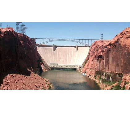
Before Glen Canyon Dam was constructed, the Colorado River’s maximum flow was 210,000 cfs, and it typically reached peak flows of 85,000 cfs every two years. Today, the typical annual peak flow is 32,000 cfs, since that’s the maximum outflow from the dam that can also generate power. Releases above that are worthless from a cash-generating perspective.[24] In the latest twist at Glen Canyon Dam, dam operators have discovered that the four 8-foot wide outlet tubes at the base of the dam have been damaged by cavitation which happens when small air bubbles pop when passing through the tubes, creating shock waves that tear away protective coating on the insides of pipes. If Powell Reservoir falls below the power generating turbines at 3,490 feet above sea level, the outlet tubes at the base of the dam have limited capacity, so they may be unable to deliver the water needed to fulfill the Upper Basin’s required delivery of 7.5 million acre feet each year. That could cause unexpected cuts in water deliveries to California, Arizona, and Nevada.[25]
The Roaring
Laboratory experiments cannot duplicate the extremely high flow events that nature produces, and hydrologists do not know much about what happens along the riverbed during flood. In June 2015, the Roaring Fork River flowed higher than it had since 1995 thanks to a “miracle May” rainfall and because the Twin Lakes Reservoir and Canal Co. was curtailing its customary diversions under the Continental Divide. I could hear rocks bouncing along the riverbed in the Woody Creek “Toothache” section above Basalt while kayaking down the river at 3,000 cfs. In the past, the Roaring Fork was not confined to a single channel once it reached the Basalt floodplain, as it is today. Rivers will naturally form braids and jump between channels as cobbles dropped in one braid raise the riverbed high enough that another braid becomes the path of least resistance. The roads and houses we’ve built alongside rivers no longer allow the river to jump to historic braids. By confining the river to a single channel, as we have done through the town of Basalt, we have interfered with the natural flow of the river. Rivers in equilibrium neither aggrade nor degrade, but instead transport material downstream so that the riverbed and slope remain constant. The climate can affect whether rivers are aggrading (adding material), or degrading. During the many glacial epochs of the just-completed Pleistocene era, Colorado rivers aggraded and floodplains grew when glaciers reigned, as the debris churned out at the bottom of glaciers was uniformly distributed into floodplains. After the glaciers melted, deep channels were cut in the alluvium. Rivers will down cut at different rates depending on the hardness of the rock layers. The next time you drive on I-70 through Glenwood Canyon, notice the banded sedimentary layers that lie above the harder Precambrian layer of metamorphic rock.[26] The Colorado River could cut through the limestone faster than through the harder Precambrian metamorphic layer, which is as tough as granite. The rate of downcutting in the Colorado River also influenced the rate of downcutting in the Roaring Fork Valley—as downcutting slowed in the Colorado River canyon, downcutting would have also slowed in the Roaring Fork Valley since it would not cut deeper than the Colorado River canyon. Vertical drop is the biggest determinant of floodplain down cutting, and rivers will down cut until they reach the level of the next river tributary they merge into. Proof of this lies in the deep side canyons that flow into the Colorado River in the Grand Canyon—although they are normally dry, the side canyons have been down-cut to the level of the Colorado River. Rare but huge runoff events are washing away canyon material in the side canyons rather than the steady flow of a river.[27]
If we view river tributary systems from above, the number and length of tributaries also follow natural rules. When small tributaries join to form larger streams, hydrologists describe each set of descending streams as “orders.” The highest streams in the drainage are first-order streams, the streams they flow into are second-order streams, and so on. Each order has 3.5 branches on average, and each order stream is 2.3 times longer than the tributaries that flow into it.[28] There is an equal drop in elevation for each stream order in a well-developed network of channels. The channel network is guided by tendencies toward a most probable state. Hydrologists repeatedly emphasize that a river’s tributaries are random. Hydrologists built models that tried to predict where tributary and higher order streams are located on real landscapes, and they came closest when stream twists and turns were modeled randomly. Rivers try to do the least work, and this is accomplished when basin areas of a particular order are reasonably equal in size and have reasonably equal channel slopes and relief.
Every dam we create interferes with these natural geologic processes. As we continually divert water to the Front Range or into irrigation ditches, there is less river flow moving material downstream. But our mountains are continually wearing away, and the precipitation that sheet washes sediment into rivers is still falling on Colorado mountains. To the extent we interfere with the natural floods that would carry sediment, gravel, and cobbles away, we risk raising the floodplain. That will make floods worse. One way to prevent this is to shut down all diversions for a few days during peak runoff every year so that rivers exceed their bank-full level. Water buffaloes complain that would result in the significant “loss” of water downstream. However, since there’s a compact obligation on every major river leaving Colorado, that “loss” is satisfying another state’s legal entitlement, as well as Colorado’s legal obligations. I think this concept merits more discussion. I’ve never understood how some people feel water flowing down a river is “wasted,” especially when the state has compact obligations. It seems that Colorado could easily declare certain times of year “non-diversion” days in order to meet downstream obligations. It would improve river health and be easier than trying to set up a demand-management scheme where irrigators submit bids to be compensated for not diverting from rivers.
The World Rivers Institute says that dams now intercept more than a third of the world’s rivers as they head to sea, trapping 100 billion tons of nutrient rich sediment that would otherwise replenish farms, deltas, and coastal zones. The Colorado, Rio Grande, Indus, Nile, and Yellow rivers, five of the most iconic rivers on earth, no longer reach the sea.[29] Two of these rivers, the Colorado and the Rio Grande, originate in Colorado. How do we make sense of 100 billion tons of sediment? If dams were holding back that much in just the continental United States, I estimate that 100 billion tons would cover every square inch of every acre in the lower 48 states with 1 cm (0.4 inches) of sediment, every year.[30] That is twice as fast as the Himalaya are rising![31] Of course, many of these dams are located on other continents, but only China has more dams than the United States.[32] The scale is much bigger than we realize, which is why geomorphologists, the geologists who study landforms and how they are created, say that humans are having such an enormous impact on earth.[33]
For example, since we removed two dams on the Elwha River in 2012 in Washington’s Olympic Peninsula, the sediment held back over 101 years has already added over one hundred acres of beach where the river meets the sea in the Strait of San Juan de Fuca.[34] That’s equal to nearly a hundred football fields! After the dams were removed, 10.5 million metric tons of sediment held behind the two reservoirs moved through the Elwha’s river system. That’s enough sediment to deposit 12 inches over a square mile. The sudden increase of sediment caused the riverbed to aggrade, raising it by about one meter. The channel morphology changed from pool-riffle to braided, and the slope of the lowermost river decreased. Steven Hawley writes about the Elwah River in Cracked: The Future of Dams in a Hot, Chaotic World, a book about dam removal that the Patagonia Foundation published in 2023.[35] The Elwah River is in the Olympic Rain Forest, part of Olympic National Park, which means federal funds have been available for the dam removal and restoration. The price tag is about $350 million, but nearly $300 million was spent on a new water treatment facility at Port Angeles and for two fish hatcheries to breed wild salmon and to release them in the Elwah in hopes they can re-establish the salmon runs. Critics say the hatchery-raised fish are inferior to the wild salmon they interbreed with, actually lowering their survival rate, and that gets passed on to later generations.
The fish runs probably would have happened anyway, like the beaches that have come back where the Elwah reaches the Pacific Ocean. Over the 100 years the two dams were in place—they were built in 1913 for hydropower—residents along the coast built retaining walls called revetments to armor the beach and keep their patch of the coastline intact. That just moves the wave-scouring force to the next adjacent beach that isn’t armored. When a property with a half-mile of beach where the Elwah met the sea came up for sale, the Coastal Watershed Institute, a local nonprofit, stepped in. “So we wrote some grants to purchase the land, with the idea of getting rid of the armor and restoring the beach,” Anne Shaffer, executive director and chief scientist, says. “Well, we did it. And in one twenty-four-hour tide cycle—in one day—the beach came back.” Armoring is by no means unique to the Elwah coast. Nationwide its estimated that 14 percent of the coast in the lower 48 states has been armored, and 64 percent of the coastline next to estuaries and coastal rivers. That’s astonishing, nearly 2 of every 3 miles! There are probably similar statistics for river front properties. It’s probable that in nearly every case the ecosystem has been damaged. Scientists are new to this dam removal business, and they’re also learning by doing. At the mouth of the Elwah, one of the most stunning benefits has been the change to the nearshore, the ocean that is just off the coast. It has filled in with boulders and cobbles, raising the sea floor and leveling off the steep dropoff that had occurred over 100 years. It’s creating new fish habitat, and surf smelt have rebounded. Shaffer says the nearshore recovery has become the poster child of the project.
Hawley’s most intriguing chapter in Cracked is “Dam Removal 101,” a citizen’s guide that sounds a lot like the roundtable process: get all the stakeholders together, go to a ton of meetings, listen to concerns, convene experts to conduct studies, and build enough critical mass to get the job done. Removing the concrete is the easy part. Don’t be put off by all the meetings—we’re social creatures as Yuval Noah Harari writes so convincingly in Sapiens—and those other people in the room eventually become friends, and that’s when you can accomplish something.[36] The main justification for keeping a dam is often because it produced hydropower, but that is becoming more and more dubious with each passing year, as solar and wind energy get cheaper. On June 20, 2024, The Economist reported that by 2070 the world will get more electricity from solar energy at current growth rates than all the electricity we used worldwide in 2023. Alone among all energy sources, solar energy has continued to drop in price as it becomes more ubiquitous—the cost of other energy sources like coal and oil have remained steady adjusted for inflation. The article said that environmentalists correctly predicted solar power growth rates at rates far higher than fossil fuel energy companies said was possible, and even they underestimated the growth. It is harder and harder to justify dams by the hydroelectric energy they produce. In Deadbeat Dams, former Reclamation chief Daniel Beard writes that we should abolish the bureau and start the dam-removal era in the United States, beginning with Glen Canyon Dam which is arguably the worst dam ever built, as it was for no good reason, and it drowned Glen Canyon. The few who floated Glen Canyon in the 1950s said it was more beautiful than the Grand Canyon, today recognized as the best river trip on earth.[37] Daniel Beard’s recommendation to remove Glen Canyon Dam is remarkable—it’s as if a former CIA chief says we should abolish the CIA and start the no-spying era. Beard says that the water nobility (his term for the water planners and managers) start with the answer—a new dam—and then work backward to find the facts to support it.
A draft of the 2015 Colorado Water Plan called for nearly 100 new dams or dam enlargements and suggests that we could store 1.7 to 4.4 million more acre-feet in 323 of our 1,953 existing dams. The data was revealed in a table in a July 2, 2015 draft that did not make it into either of the published 2015 or 2023 state water plans [38] It does not say what impact holding the water back would have on river health or our interstate water compact obligations. The word “dam” shows up 11 times in the published 254-page 2023 Plan, but “storage” comes up 192 times, nearly once for every page. “Dams” are not politically correct while “storage” is, masking the fact that they each say the same thing. And dam storage is present on nearly every page of the Colorado Water Plan. Beard is not the only person calling to remove Glen Canyon Dam. The Sierra Club called for its removal in 1996, following the lead of its first executive director, David Brower, who blamed himself for accepting Glen Canyon Dam as a political tradeoff for eliminating Echo Park Dam. Echo Park Dam would have flooded both the Green and Yampa rivers with a 529-foot high concrete gravity dam in Dinosaur National Park. As with the Two Forks Dam and Reservoir Project, the dam was proposed just downstream of a confluence (in this case, of the Green and Yampa rivers) so both upstream river forks would flood. The Glen Canyon Institute, based in Salt Lake City, has been campaigning to “Fill Mead First,” a proposal to draw down Lake Powell as much as possible, storing its water in Lake Mead instead. That would not only restore much of Glen Canyon, it would also cut back evaporation to a single reservoir. Evaporation would still be great since Lake Mead is a larger reservoir at a lower elevation where it is hotter and evaporation is greater. Evaporation is getting harder to ignore, despite the 1922 Colorado River Compact doing just that. The Upper Division states are now stating what has been obvious for a long time, that “Lower Basin consumptive uses and depletions from evaporation and losses must [be] balanced with actual supply.”[39]
Dams have an optimal size, generally when storage capacity is great enough to hold back high flows. They reach a point of diminishing returns, where the increased storage is offset by increased evaporation. The amount varies based on factors like inflow, what the water will be used for—irrigation or power generation—when it is needed, and how much evaporation occurs. Some Colorado politicians clamored for more storage on the Front Range to capture floods like the 2013 Boulder flood, but such floods happen so rarely that the annual evaporation can exceed the additional water held back from the occasional flood, resulting in no net gain in the long run. Building a dam to hold back an occasional flood makes good press, but it may not realistically solve any problems. In 1959, U.S. Geological Survey engineer Walter Langbein said, “There is a limit to the amount of storage that can be useful. The Colorado River basin is an example of a river basin where storage development may be approaching, if not exceeding, its useful limit.”[40] He continued, “There is no significant gain in net [additional storage] between 29 and 78 million acre-feet of capacity.” The reason for this is evaporation—although additional storage capacity allows more water to be held back, the increased evaporation results in little or no additional water released from reservoirs. Langbein estimated that increasing reservoir capacity in the Colorado River Basin nearly three-fold from 29 to 78 million acre-feet would result in only 5.5 percent more water released.
As the graph below shows, we nearly reached 29 million acre-feet when we completed Hoover Dam in 1936. Lake Powell, shown in gray, lies completely outside of the storage limit that Langbein considered “optimal.”
Figure 3.1 Chart of storage capacity in the Colorado River basin
I wonder if Langbein received any flack for his paper, written while Glen Canyon Dam was under construction. Lake Powell began filling barely three years later, on March 13, 1963. The reaction of western politicians on Capitol Hill to the Sierra Club's proposal to decommission Glen Canyon Dam ranged from "nonsense" to "absolutely ridiculous" to "a certifiably nutty idea."[41] Langbein may have privately used similar language to describe the net benefit Lake Powell would produce. Our kids might be using the same language when they have to deal with a Lake Powell that is completely silted in. Lake Powell and the other reservoirs in the Upper Colorado Basin were built to hold back enough water so the Upper Basin could develop its share of the Colorado River and also release 75 million acre-feet every ten years to the Lower Basin states. But as authors Kuhn and Fleck conclude in Science be Dammed, the Law of the River and the dams and water infrastructure governing the Colorado River reflect an “effort to maintain a fiction of plenty of water in the face of a reality of less.”[42]
Dams also protect against flood damage, and Langbein emphasized that his analysis of optimal storage did not apply to dams built to control floods, like Chatfield Reservoir on the South Platte River upstream of Denver. All dams indirectly reduce the risk of flooding by simply holding back silt, preventing it from being deposited on the flood plain. Over time, a rising floodplain will increase the risk and extent of floodplain flooding, so dams ostensibly lower this risk. On the other hand, flood velocities are increasing on many Colorado streams. This is partly because we are straightening river channels, often by building roads alongside them. Homeowners who anchor the banks along their riverfront properties with rocks or riprap also cause the river to rush faster downstream. By reducing the incidence of natural flooding flows, trees and other plants are maturing and anchoring the banks. This prevents rivers from naturally shifting and meandering. When it does flood, the river velocity is greater, with potentially catastrophic consequences.
Irrigation Near Kremmling
In the upper Colorado River below Granby, many irrigation ditches between Hot Sulphur Springs and Kremmling ran into difficulty because river flows were no longer high enough to reach the irrigation diversion ditches. Was this because the riverbed dropped since Lake Granby and Windy Gap Reservoir are holding back sediment and bedload that would normally replenish the riverbed? Or was the riverbed rising, or aggrading, because low flows no long remove the sediment and bedload that does reach the river? Ken Neubecker, the former environmental representative on the Colorado Roundtable, believes the problems started when a rancher cut off a meander in the river above Kremmling decades ago.[43] That concentrated the drop that had previously coursed through the meander into an abrupt vertical drop, also known as a “head cut” or “knickpoint.” A small plunge pool often forms at the base of the head cut due to the higher energy of falling water. As erosion of the knickpoint and the streambed continues, the head cut migrates upstream. As the knickpoint worked its way upstream, the riverbed level fell below the level of the irrigation ditches one by one, causing many of the problems now being experienced by irrigators. Every river is different, “the carpenter of its own edifice,” as Leopold said.
Northern Water, which stores water in Granby Reservoir on the upper Colorado River, has spent decades and millions of dollars to reverse irrigation problems downriver near Kremmling. The Colorado Roundtable and the CWCB have awarded grants exceeding $1 million to ranchers near Kremmling to pay for engineering studies to determine what can be done to fix the river, and whether prior attempts have made the situation worse. Ranchers historically placed “drop structures” in the river, a fancy term for a line of large boulders placed across the river that raise the water level high enough to divert the river into irrigation ditches. Drop structures have limited lives. Rivers are naturally bowl-shaped from the headwaters to the plains—starting out steep, they gradually flatten as they descend, striving to remove any obstruction in the riverbed that disturbs the river’s smooth parabolic profile.[44] When high flows pour over a drop structure they scour the pool below until the drop structure eventually collapses. Afterward, the riverbed is no longer high enough to divert water into the irrigation ditch, leaving the ditch high and dry. Drop structures also cause clay sediment to settle out further downstream below the now larger scour pools. Clay can act as an anchor and cement rocks in place, causing the riverbed to effectively become a wasteland. In can also strengthen the river bottom relative to the banks, causing riverbanks to erode more than they otherwise would.
In Colorado, Grand County has struggled for decades to improve the dewatered Fraser and Colorado rivers above Hot Sulphur Springs. And so the Colorado River has now been re-routed around the south side of Windy Gap Reservoir, effectively cordoning off the water body and turning it into an off-channel reservoir. The fix by Northern Water permits the Colorado River to once again flow unimpeded around Windy Gap reservoir so that fish can migrate up and down the river. The late Lurline Underbrink Curran, who served as Grand County manager and represented the county for years on the Colorado Basin Roundtable, once said that Windy Gap Reservoir is the lynch pin that the rest of the upper Colorado River’s health relies upon. And yet the riverbed below Windy Gap Reservoir is so armored that high flows in 2014 and 2015 failed to mobilize rocks in the streambed. Grand County plans to bring backhoes into the river to rip up the riverbed. The armoring will likely persist unless we permit the Colorado River to flow high enough and often enough to regularly mobilize the bed load (called channel maintenance flows). The river also needs an adequate supply of sand, gravel, and sediment to maintain a healthy stream bottom, and sufficiently high flows to periodically flush the sediment downstream (called flushing flows). This depends on how much water Denver Water permits to flow down the Fraser River every year. When Gross Reservoir on South Boulder Creek triples its capacity , Denver Water will take even more water from the Fraser River and its tributaries, another 18,000 acre feet annually. When we started keeping river flow records, the upper Colorado River reached 12,000 cfs at Kremmling twelve times in the twenty years between 1900 and 1920. Those flows are almost never seen today, occurring only once since 1980.
Healthy rivers need to resemble the natural hydrograph, the annual river profile showing flows that gradually ramp up in the spring to a peak, and then ramp back down gradually. It is not enough to simply release a large pulse flow down the river for a couple of days. Rapid fluctuations can erode beaches, as we’ve observed in the Grand Canyon for decades. Excessive erosion is a sign that the river is out of equilibrium. The CWCB refuses to admit that rivers should resemble the natural hydrograph. I once wrote an early draft of the environment-centric “Point 7” in the Conceptual Framework, a working agreement guiding how a new transmountain diversion from the west to the east slope might be developed. I described what is needed for a healthy river, but members of the environmental community chided me and told me to take out the phrase “natural hydrograph.” Point 7 did end up saying that rivers must be environmentally resilient, noting that “environmental resiliency and recreational needs must be addressed both before and conjunctively with a new transmountain diversion.”
Upstream along the Fraser River, which drains Berthoud Pass and runs past Winter Park, they are trying to repair the river, damaged by existing transmountain diversions, with engineering solutions, instead of with regular high flows. Engineers propose to narrow the stream channel by deepening it and reinforcing the sides with boulders, known as stone toe protection, to keep the narrowed river channel in place. Additional boulders can also be placed on the river bottom to slow velocity and create scour pools below boulders, habitats that fish prefer. With low flows come hotter temperatures, and trout prefer cooler water. Stream temperatures have been reaching 70o F (21o C) on the upper Colorado and Fraser rivers. There are two solutions to this—planting trees or letting more water run downstream—and we know which one Denver Water and Northern Water prefer. So, engineers are planting trees and installing lunkers, crib-like structures made of wood the size of railroad ties that are placed under riverbanks. Lunkers, which stand for “Little Underwater Neighborhood Keepers Encompassing Rheotactic Salmonids,” allow water to flow underneath the banks where it stays shaded and cool. Not everyone considers them a best practice. Luke Annear, a part time fly fishing guide in Wisconsin, prefers “watershed restoration over stream improvement. Restoration that sets nature on a course to sustain itself without frequent—if any—continued intervention” is better.[45]
There are some other helpful things that can also be done to help rivers.
“Rosgen structures,” which strategically place boulders in an upside-down U shape in the river when viewed from below, can replace the rows of boulders that irrigators traditionally place horizontally across the river to divert water into irrigation ditches. Horizontal drop structures often fill in with cobbles that must be regularly dug out, and they also create unnatural waterfalls that are hazardous to boaters. Farmers have a specific exemption so they do not need a 404 permit from the Army Corps of Engineers to drive their backhoes into the river to dig out drop structures clogged with cobbles. Rosgen structures, named for Dave Rosgen, the Colorado engineer who proposed them, can eliminate this regular river disturbance. They divert sufficient river flow to fill diversion ditches while maintaining enough velocity in the main channel that the river can still move cobbles downstream. They also permit drift boats and rafts to maneuver safely through them.
Another healthy river recommendation is to permit beaver to inhabit streams whenever possible. Beaver, especially in smaller streams higher up in river basins above the zone that cities occupy, make rivers healthier because they increase the amount of water that is stored both above and below ground. Groundwater held behind beaver dams is just as important as the water stored above ground.
Fish bypass channels can allow fish to get around drop structures that are too high or turbulent. Fish bypasses have failed to stem the decline of endangered fish in the Colorado River like the pikeminnow, but they can help fish navigate around irrigation diversion structures on smaller rivers in Colorado.
Sean Cronin, executive director of the St. Vrain and Left Hand Water Conservancy District and longtime member of the South Platte Roundtable, was involved in repairing irrigation diversion structures that were destroyed in the 2013 Boulder flood. He lamented in 2017 that many structures were replaced exactly as they had been previously built, without regard to their impact on fish migration. If fish friendly engineering designs had been available, Cronin said during a meeting in the Roaring Fork Valley, we could have pulled them off the shelf and replaced the impassable barriers. He said there wasn’t time to design them between the September 2013 flood and the 2014 irrigation season, so most structures were rebuilt just like before. But river restoration specialist Jeff Crane, who had been advising the state on flood recovery since 2013, said at a 2017 meeting in Carbondale, “There were plenty of fish friendly designs available from Colorado Parks and Wildlife and other engineering companies if the ditch companies wanted to implement them.”[46]
Another innovation slow to take root in Colorado is the Rubicon ditch headgate structure. They are solar-powered diversion structures that constantly adjust to minimize how much water is diverted from the stream, replacing the cast iron diversion gates that farmers typically open in May and close in October. Rubicon devices are ubiquitous in Australia where they were designed, but practically unheard of here because they interfere with “use it or lose it.” Under Colorado water law, irrigators believe, and water commissioners and judges tacitly acquiesce, that any water left in the stream will decrease water rights in a zero-sum game. Dennis Davidson, who worked for years for the Natural Resource Conservation Office in Glenwood Springs, said at a 2015 Colorado Roundtable meeting that “when the court decreed the water right, the NRCS assumes the judge did an efficiency beneficial use analysis. Forty acres for one cfs is how judges issued water rights. How do you get a better handle on it? Make everyone drip irrigate? We can, but at what cost? You can’t retrieve your costs if you grow hay on rocky soils. The best system is wild flooding on steep hillsides. The rancher’s still irrigating, he’s doing the best he can.”[47]
Judges do not do efficiency analyses. They adjudicate disputes, and the only time they order a person to leave water in the stream is when a senior water right is calling for it. Once thing is certain, modified rivers are expensive to engineer, build, and maintain. Transmountain diverters grumble that engineered improvements are too expensive to be cost-effective, but this should be a cost of doing business. River management practices also need to adapt when engineered solutions fail to deliver the intended stream benefit. If the solutions do not work so that rivers are getting too hot, or the bed is being armored, we have to try plan B, which usually amounts to leaving more water in the river.
A decade ago, the cost to reconfigure streams was estimated at $150,000 per mile for smaller scale river restoration, and $240,000 to $500,000 per mile to reconfigure whole channels. The 2015 water plan estimated it would cost $18 million to prepare stream management plans for ninety watersheds.[48] At $200,000 per plan, this is only one-tenth of the $2 million that Grand County spent on its stream management plan for the upper Colorado and Fraser rivers. In all, the 2015 state water plan estimates it will cost $2-3 billion for environmental and recreation needs, about 10-15 percent of the overall $20 billion estimated cost of the plan. The $17-18 billion remaining cost is for municipal and industrial infrastructure, most of which will be targeted to holding back still more water in dams or diverting still more water from rivers. The 2015 state plan did not list the projects that total up to $20 billion dollars.
The Statewide Water Supply Initiative process (SWSI) identified 18,767 stream miles with important riparian and wetland areas in 2010. Only 27 percent of these have any known protections in place.[49] Many of the “protections” are dubious, such as instream flows that are so junior they do not provide any realistic benefit when river flows are low. More often than not, the problem is low water flows.
River Resilience
Resilience is the ability of a system to cope with change. It can be defined in several different ways, such as the time it takes to return to equilibrium, or as the capacity to bounce back after a disturbance. [50] Some disturbances are so great that systems cannot recover. Forests that lose more than 10 percent of their cover due to landslides or lightning have a difficult time recovering. But rivers and riparian environments can recover surprisingly quickly if you just add water or remove dams or curb pollutants from flowing into them. Low flows on the Colorado River do not just hamper irrigation, they also harm aquatic life. Brian Bledsoe and his students at Colorado State University received a Colorado roundtable grant of $70,000 to do a synoptic survey of the river below Windy Gap, a scientific name for sampling the river at the same locations at different times during the year to measure river changes. They studied the Upper Colorado River from Granby to Dotsero. Bledsoe’s students conclude that peak stream flows of 12,000 cfs are needed every few years to mobilize large rocks on the river bottom and move them downstream, the channel maintenance flows we’ve discussed earlier. Such flows used to be common, occurring in nine out of fourteen years from 1905 to 1918. That is admittedly a high-flow era, but in the last fifty-seven years since 1962, they have occurred only once, in the El Nino year of 1983.[51] In addition, annual flows of 4,000-8,000 cfs are needed to remove fine sediments. These are known as “flushing flows.” In recent years, the Colorado River has only reached 8,000 cfs in the high-water years of 2011 and 2014[BG1] . How long the high flow lasts is not as important as size of the flow, but high flows must be released gradually—ramping up and ramping down too quickly will damage the overall health of the riparian corridor and the life-forms living in it. Finally, Bledsoe’s team says more water needs to be released in July and August to keep river “baseline flow” temperatures cool.
A number of reservoirs are available to release water down the Colorado River including Green Mountain, Granby, Williams Fork, and Wolford Mountain reservoirs. When Williams Fork released 236 cfs on June 6, 2012, the Colorado River’s temperature dropped 10oF from 69oF to 59oF. When a release from Green Mountain Reservoir increased river flow from 166 to 776 cfs, the Colorado River was 6oF cooler 60 miles downstream at Dotsero. We could also release peak flows to tumble rocks down the river channel. Bledsoe’s students reported that fine sediment increased in the locations they sampled as they moved down river. That affects macro-invertebrates, the bugs that fish feed on.
In Colorado, and particularly on the Western Slope, water diverted to grow hay is the main cause of river degradation. What is so maddening is that our antiquated water law, literally born in a mad free-for-all by miners speaking different languages near Central City in 1859, is driving this. When a gentleman rancher leaves a real estate closing after purchasing his Colorado trophy ranch, the last thing he may hear from his attorney is, “Make sure you keep diverting your water rights, otherwise you’ll lose them.” Drying up a mountain stream, even if only for a few days in late summer, is equivalent to cutting a person off oxygen for six minutes. It’s fatal. It’s also completely legal. Right now, water law in Colorado encourages people to take as much water from the river as they can. What if we turned this on its head and instead said, leave as much water in the river as you can? I’m convinced we could leave 30-50 percent of the water we now divert from most Western Slope rivers without losing a single irrigated acre by simply reforming our law and irrigation practices. Statewide, I estimate we could increase annual river flows by 40 percent by sprinkling fields rather than flood irrigating them. This is controversial whenever I utter this, but we will never find out until we pick a flood-irrigated basin in Colorado to try it out. Our rivers are unhealthy in the West because we slavishly follow outdated laws and practices, disguised under the mantra that we need to do this to protect family farms. Curran Underbrink of Grand County said flood irrigation is necessary to replenish river flows in late summer and fall in the upper Colorado River. When that is true or if wetlands are maintained by return flows, then a case can be made to flood irrigate hay fields. But the real reason the upper Colorado River gets so low is because we divert 300,000 acre-feet a year from it. Strategic releases from Granby and Williams Fork reservoirs could keep more water in the upper Colorado River instead of relying on flood irrigation return flows.
Many would prefer that I muffle my concern about excess irrigation diversions, fearing that if we leave more water in west slope rivers, the east slope will just come over and take it. For as long as this is the case, we will keep drying up west slope rivers because it is better than the alternative of leaving water in the river that the east slope will swipe. But it doesn’t make the practice any less stupid, and it is hell on fish and the environment. We need to agree as a society that leaving water in rivers is more important than taking water out of them. This means the east slope has to agree that if we leave more water in west slope rivers to improve the environment it will stay there. This is what I call the “grand bargain,” which I feel must be made if we ever get serious about protecting the health of our rivers and streams. Another convenient objection is that any water left in rivers will just go into Lake Powell and give Californians a windfall. Water buffalo legislators used this excuse to justify why they could not support Sen. Schwartz’s failed bill to leave irrigation efficiency savings in the river. Ahem, Lake Powell was at about its lowest level ever when Senator Schwartz’s bill was defeated in April 2015, and it is lower in 2024, dropping at one point to only 32 percent full, and warming temperatures will likely exacerbate the low river flows we’ve been seeing since 1999. Lake Mead and Powell were only 40 percent full in April 2015, and their combined volume was barely 56 percent of their average volume since 1972. We must leave water on the Western Slope and let it flow downstream into Lake Powell or else Colorado will be forced to deliver it to meet a Compact Call. And we can reduce diversions without eliminating agriculture.
At a 2014 water meeting a young engineer asked me if I was against prior appropriation. Surprised by the question, I assured him that I’m not. If you’re first in line, you get to go up the ski lift first and you get the first tracks! But when it comes to water, we let whoever is in line take it all, here in Colorado and throughout the West. When it comes to water, if you’re first in line you can exclude others from the line. That’s what bothers me. That, and the fact that the river is always last in line for its own water. And if we expect the agricultural community to pay to modernize 19th Century irrigation ditches, it won’t happen. Most farmers lose money and they’ll protest if they have to install screens to keep fish out of irrigation ditches or if they have to pay for solar-powered Rubicon ditch diversion structures that only withdraw water from rivers when it is needed for irrigation. One way to raise money to modernize irrigation ditches is to encourage utility customers to make donations on their monthly utility bills. Holy Cross Energy customers in Glenwood Springs and the Roaring Fork Valley can contribute $5, $10, or more each month to purchase wind energy from Nebraska. CSU professor James Pritchett polled water utility customers throughout the West, and over half said they would contribute $5 to $10 a month to raise money to keep farms from being dried up. If half of Denver Water’s customers contributed $5 per month, this would raise about $10 million a year.[52]That’s less than 4 percent of Denver Water’s typical annual revenue, but it would provide $100,000 to improve each of 100 ditches. Will this work? We won’t know until we try. I know I would contribute. Today, no such funds exist because, as a water engineer told me, his client “wasn’t interested in leaving water in the river.”
The 2015 state water plan suggests that $20 million is needed to prepare stream management plans. If this is targeted to determining the quickest and most effective ditch structure improvements, it will be money well spent. But if the money is spent determining the minimal amount of water a stream needs to survive, that will benefit a few consultants, not rivers. We know how much water Colorado rivers need, and the answer is always “more.” And although it carefully avoids the topic, the unwritten message of the 2015 and 2023 Colorado Water Plans is that we need more dams. Dams serve human needs, but no natural needs. The following passage describes the harm that dams cause. It is taken verbatim from the Programmatic Biological Opinion that the U.S. Fish and Wildlife Service prepared in 2009 to explain how much water was needed in the Gunnison River to protect the four endangered fish species in the Colorado and their critical habitats. “Major declines in pikeminnow populations occurred in the lower Colorado River Basin during the dam-building era of the 1930s through the 1960s. Dams, impoundments, and water use practices drastically modified the river's natural hydrology and channel characteristics throughout the Colorado River Basin. Dams on the main stem fragmented the river ecosystem into a series of disjunct (sic) segments, blocked native fish migrations, reduced water temperatures downstream of dams, created lake habitat, and provided conditions that allow competitive and predatory nonnative fishes to thrive both within the impounded reservoirs and in the modified river segments that connect them.” It also said that “it is unknown how many endangered fish are lost in irrigation systems, but in some years, in some river reaches, the majority of the river flow is diverted into unscreened canals.” [53]
Andre Wille, retired Aspen High School science teacher and longtime member of the Pitkin County Healthy Rivers Board, says you can determine river health by studying its macro-invertebrates, the bugs that live in the river and feed trout. A healthy river includes cold water temperatures and a wide range of species including caddis flies, stone flies, and may flies. If there is a healthy fish population it’s almost certainly due to a healthy bug population. “High stream temperatures result in lower dissolved oxygen, and that hammers bug populations that rely on cold, fast-moving rivers. Other bugs do well in low oxygen, muddy bottoms like tubifex worms,” Wille says. Tubifex worms commonly thrive in sewers and serve as a vector for whirling disease; they are in the Colorado River below Windy Gap Reservoir.[54] When the interstitial spaces on river bottoms get clogged with silt and flushing flows no longer remove it, macro-invertebrates decline, and so do fish. Biologists have known this for a long time, and we’re taking baby steps to address it on the Fraser and Colorado river headwaters in Grand County in the “Learning by Doing” program. Denver Water and Northern Water are participating in that program, but only as a concession for taking another 48,000 acre-feet to the Front Range each year with Chimney Hollow Reservoir is completed and Gross Reservoir is expanded. The 2015 Colorado Water Plan says repeatedly that the best we can do is reach low to medium levels of municipal conservation, and that we must keep as much water in agriculture as possible. That leaves only one solution for our water supply gap, according to the state: more dams or greater diversions into existing dams.
At the very first Colorado Basin roundtable meeting I attended in December 2005, Rick Brown of the CWCB said, “Tell us which rivers are most important to you, and we’ll do what we can to protect them.” My jaw dropped, because the answer was so obvious to me, every one of them! It is the height of human hubris to think we can sacrifice a river.
Notes:
[1] “Questions About Removing Dams,” American Rivers.
[2] Every one of Colorado’s reservoirs can be viewed at “Colorado Reservoirs”, U.S. Gazetteer, downloaded July 17, 2016, http://colorado.hometownlocator.com/features/cultural,class,reservoir,alpha,m.cfm.
[3] Dolores County has 1,064 square miles, ranking 42 of 64 counties; 2,064 persons in the 2010 U.S. Census; and a population density of 1.9 persons per square mile, 55th lowest in the state.
[4] Hawley, S., “Cracked The Future of Dams in a Hot, Chaotic World,”, Patagonia Press, pgs. 196, 306, 2023.
[5] Leopold, L., 1994, A View of the River, Boston: Harvard University Press, 3.
[6] Jeff Lukas supplied these figures at a speech given at the Colorado Groundwater Conference, Denver, December 4, 2014.
[7] “How the Earth Works,” The Teaching Company, 2008, Lecture 34, Prof. Michael E. Wysession, Washington Univ., St. Louis.
[8] Pool-riffle sequences occur in a distance of 7.4 river widths (if the river is averages 10’ wide, a pool and riffle will occur every 74 feet on average). This distance efficiently distributes the down-cutting power of the river as water flows downstream. Leopold, pg. 28.
[9] A collection of 183 of Luna Leopold’s papers are available online at the “The Virtual Luna Leopold Project,” downloaded October 11, 2015.
[10] Meine, C., “Lessons Learned from a Legend: Luna Leopold’s View of the River,” Oct. 7, 2015, U.S.GS.
[11] Burk, A., “Colorado Thrives When Our Rivers Do,” Audubon Rockies, downloaded June 19, 2024, https://rockies.audubon.org/blog/rivers/colorado-thrives-when-our-rivers-do
[12] Rivers typically meander through two full turns in a distance of about eleven times the width of the river, with most meanders occurring between 10-14 river widths. The meander radius also follows a natural law, with the radius typically equal to 2.3 river widths. This relationship holds true from small brooks to the Mississippi. Leopold, pg. 60.
[13] Fielder, John, 1999, Colorado 1870-2000, Westcliffe Publishers.
[14] Webb, R., Leake, S, and Turner, R., The Ribbon of Green, Change in Riparian Vegetation in the Southwestern United States, Tucson: University of Arizona Press, 2007. The authors, two of whom worked were research hydrologists and the third a botanist, all with the USGS, conclude that “Contrary to the common assumption of widespread losses of [woody riparian vegetation] . . . vegetation has increased on many river reaches as a result of flood control, favorable climatic conditions, and large winter floods that encourage ecosystem disturbance, germination, and the establishment of species in newly generated openings.” Id, inside flap.
[15] Shafroth, P., “Saltcedar (Tamarix spp.) and Russian Olive (Elaeagnus angustifolia) in the Western United States— A Report on the State of the Science,” 2012, U.S.GS.
[16] Leopold, 75.
[17] Harvey, 6.
[18] “Silt,” National Geographic Education.
[19] Sackett H., “Reservoir releases will boost peak Colorado River flows this weekend,” June 7, 2024, The Aspen Times.
[20] Leopold, Table 11.1, 207. See also, “How many tons of gravel can fit in a dump truck?,” accessed July 13, 2015.
[21] Leopold, 129.
[22] Leopold, 267.
[23] Colorado Basin Roundtable meeting minutes March 25, 2024, based on the report by Schmidt J., Kuhn E., Fleck J., “Managing the Powell/Grand Canyon/Mead Ecosystem after 2026,” March 29, 2024, available in the Colorado River District meeting agenda packet for April 16-17, 2024, pages 212-222.
[24] Belize, L., “High Flow Experiments in the Grand Canyon: An Evolving Water Management Paradigm for the Colorado River,” Hydrologic Sciences, Winter 2014.
[25] James I., “Damage found inside Glen Canyon Dam increases water risks on the Colorado River,” Uintah Water conservancy District, April 16, 2024.
[26] Precambrian refers to rocks that don’t contain the fossils that started appearing 540 million years ago in the Cambrian period. The Cambrian fossil record represents the explosion of life when the earth’s atmosphere changed from a carbon- to an oxygen-based atmosphere. The Precambrian era refers to the long span before 540 million years ago to the birth of the Earth about 4.5 billion years ago.
[27] Ranney, W., Carving Grand Canyon, 2012, Grand Canyon Association.
[28] Leopold, 223, 235.
[29] Rainey, J., “My Journey to Understanding River health,” World Rivers Review, Vol. 30 No. 1, April 2015, 10. http://www.encyclopedia.com/topic/Mississippi_ percent28river_U.S. percent29.aspx. Also see Wikipedia on the Mississippi River Delta; Allison MA, et al., “A water and sediment budget for the lower Mississippi-Atchafalaya River in flood years 2008–2010: implications for sediment discharge to the oceans and coastal restoration in Louisiana,” 2012, J. Hydrol.
[30] One ton is equivalent to a cubic yard of dry dirt, or 46,656 cubic inches. The continental U.S. land area is just under 3 million square miles, 1.9 billion acres. 100 billion tons amounts to 52.8 tons per acre in the continental U.S., and that amount of sediment equals .39 inches covering every square foot.
[31] “Himalayas,” last modified Dec. 17, 2016, Wikipedia.
[32] China is believed to have more than 80,000 dams and the United States has over 75,000. “What country has the most dams?,” Infoplease, http://www.infoplease.com/askeds/country-most-dams.html, downloaded 8-8-2015.
[33] Harvey, A., 2012, Introducing Geomorphology, A Guide to Landforms and Processes, Edinburgh: Dunedin Academic Press Ltd., 6.
[34] Podmore, Z., “Elwha Unplugged,” Canoe & Kayak, August 2015, 44.
[35] Hawley, S., Cracked The Future of Dams in a Hot, Chaotic World, 2023, pgs. 171-189.
[36] Harari Y. N., Sapiens A Brief History of Humankind, 2011.
[37] Beard, Daniel P., 2015, Deadbeat Dams, Boulder: Johnson Books, 132.
[38] Colorado Water Plan, 2015, Section 4, Water Supply, table 4-4, page 74, second draft dated 7-2-2015.
[39] Letter from the Colorado River Upper Division State Representatives of Colorado, New Mexico, Utah, and Wyoming to Camille Tonton, Com’r US Bureau of Reclamation, “Additional Information Regarding the Upper Division States Alternative,” March 11, 2024, pg. 3, available at pages 155-168, Colorado River District Board Agenda April 16-17, 2024.
[40] Langbein, W., “Water Yield and Reservoir Storage in the United States,” 1959, U.S. Geological Survey Circular 409 (1959), http://pubs.usgs.gov/circ/1959/0409/report.pdf. See the table at the bottom of page 4 of Langbein’s paper, which indicates that reservoir capacity of 29 million acre-feet results in annual releases of 5.5 million acre-feet. Increasing reservoir capacity to 78 million acre-feet, nearly 3 times greater, results in in annual releases of 5.8 million acre-feet, only 5.5% more.
[41] These quotes are reported in, Miller, S., “Undamming Glen Canyon: Lunacy, Rationality, or Prophecy?,” Jan. 2000, Stanford Environmental Law Journal, [Vol. 19:121], pg. 123, http://www.livingrivers.org/pdfs/ScottMillerReport.pdf . The quotes in the text are from footnote 4: Lake Powell Hearing, supra note 1, at 62 (statement of Melvin F. Bautista, Executive Director, Navajo Nation Division of Natural Resources); id. at 18 (statement of Michael Hacskaylo, Administrator, Western Area Power Administration); Adrianne Flynn, Idea to Drain lake Powell Is Ridiculed, Ariona. Republic, Sept. 24,1997, at A1; Ed Marston, Sierra Club Moves To Fortify Its Drain Lake Powell Campaign, High Country News Oct. 13, 1997, at 5; Tom Wharton, Study Draining Lake Powell: Ex-Reclamation Head Says Idea "Fascinating " But Research Needed, Salt Lake Tribune., Oct. 10, 1997, at B2; Jason Zengerle, Water Over the Dam: The Sierra Club's Strange Bid To Drain a Lake, New Republic, Nov. 24, 1997, at 20; Utah Representative Chris Cannon introduced a resolution denouncing the proposal and touting Lake Powell's benefits. The resolution was supported by more than two dozen representatives and was referred to the committee on resources. See Lawmaker Defends Lake Powell, Rocky Mountain News, Mar. 6, 1998, at A18.
[42] Kuhn, E., Fleck J., Science be Dammed How Ignoring Inconvenient Science Drained the Colorado River, 2019, pg. 225, Univ of Ariz Press
[43] Comments made at January 9, 2017, Colorado River Basin Roundtable meeting.
[44] “How the Earth Works,” Wysession, M., Lecture 34, pg. 154, 2008, Chantilly, Virginia: The Teaching Company.
[45] Annear, L., “Humans, Streams, and the Desire to Manage,” October 12, 2019, https://edgeeffects.net/desire-to-manage/.
[46] Comments made at a Roaring Fork Collaborative meeting, Jan. 26, 2017, Third Street Center, Carbondale.
[47] Comments made at the Colorado Basin Roundtable Meeting, Glenwood Springs, August 24, 2015.
[48] Colorado Water Plan, 2015 Chapter 9: Alignment of State Resources and Policies, page 331, 7/2/2015 draft.
[49] Colorado Water Plan, 2015 Section 6.6, Environmental Projects and Methods, page 253, 7/2/2015 draft.
[50] “Ecological Resilience,” Wikipedia, last modified August 31, 2015, https://en.wikipedia.org/wiki/Ecological_resilience.
[51] Historic river flows are available online at the USGS Water Data for the Nation, http://nwis.waterdata.usgs.gov/nwis/. Click on the map and expand it to locate a gage in Colorado. Click on the gage for historic and real time flow information.
[52] In 2013 Denver Water had 312,228 active taps; if half contributed $5 a month for 12 months, that would raise $9.4 million.
[53] A word search of the second draft of the Colorado Water Plan dated 7/2/2015 yielded 102 references to “multi-purpose,” and another 19 references to “multiple benefits” or “multiple needs.” There were only 42 references to “dam” or “dams,” and most referred to dams that have already been built or discussed whether additional water could be stored in them. There was not a single passage devoted to building new dams.
[54] “Tubifex,” last modified 20 Aug. 2024, Wikipedia.
[55] "List of dams in the Colorado River system," last modified Oct. 3, 2015, Wikipedia.
